Browse Exhibits (7 total)
1. Land Walls

Google Slides Presentation.
(Spanish version)
For the images in the lesson click the link on the right. --->
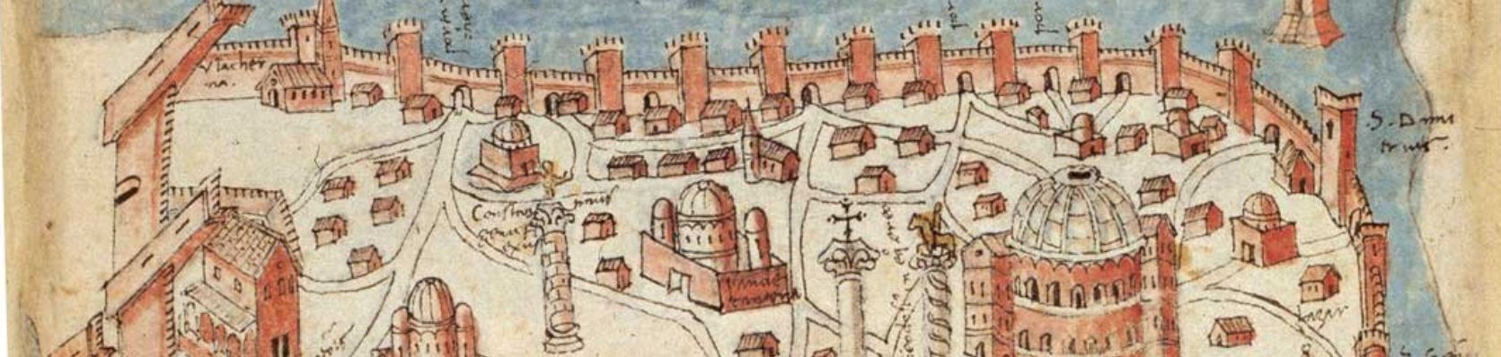
The Theodosian Walls were built in the fifth century under the authority of the emperor Theodosius II (who reigned from 408-450). Parts of these massive walls had already been constructed by then (such as the monumental Golden Gate).
These walls defined the boundaries of the City of Constantinople throughout the medieval period. They were absolutely massive: not a single wall, but three separate walls and a moat. The largest wall was the inner wall: 15 feet thick, 40 feet above the ground, and guarded by 92 towers each over 60 feet tall (here's a drone video flying the Theodosian land walls today from north to south).
But how did citizens of and visitors to Constantinople experience these walls? The city was only rarely under seige and so in day-to-day life the walls contained the great gates through which visitors and residents poured into and out of the city.
For extra information see this Byzantine Legacy website by David Hendrix.
Here are two 3-D reconstructions of the Golden Gate (Porta Aurea)
2. Mese & Fora

Google Slides Presentation
Spanish Slides Presentation
For the images in the lesson click the link on the right. --->
The Mese (which just means "Middle Street") is the Main Street through the southern part of Constantinople, from the Golden Gate to the Hippodrome (the center of the city).
For extra information: the simple map below labels each forum we talked about in class (note: the pural of forum is fora because the word is in Latin).
- The Forum of Arcadius: built in 421, with a massive column residents could climb up inside
- The Forum of the Ox
- The Forum of Theodosius: build in 393, also with a massive column residents could climb
- The Forum of Constantine: built in 330, with a massive column, and the senate house

3. Trade, Commerce, Shopping
Google Slides Presentation.
Presentación en Español.
Theodosian Harbor (war galleys, trade ships):
What will you sell at your store (play from 0:14 to 1:30)?
Here is a 40-minute documentary on the discovery of the shipwrecks from the Theodosian Harbor.
4. Hippodrome
The Hippodrome was a large stadium which served as the social and cultural center of the city and was used for sporting events, entertainment, imperial ceremonies, and other public and political events.
To be truly historically accurate, the Hippodrome would not have looked like or been used in 1350 (when your historical character visited it) in the way we describe in this lesson (which presents the Hippodrome in around the 10th century). In the sack of Constantinople in 1204 the Hippodrome was looted, and it was never restored and used again in the later Byzantine period in the way it was during the empire's glory days. Nonetheless, since it is so iconic a part of Constantinople and the civic life of the medieval Roman empire we were compelled to make it one of our Seven Wonders, even if we are being just a bit anachronistic or a-historical!
The class slide show presentation is here.
Presentación en Español.
For more on the key images from the presentation, click to the right.
Flying over the Hippodrome:
5. Basilica Cistern
To learn about the Basilica Cistern, you will learn about the water supply of Constantinople in general, including the massive Aqueduct of Valens.
Google Slides Presentation HERE
Presentación en Español (in preparation)
This five-minute video made by Byzantium1200.com gives you an overview of Constantinople's water supply:
6. Hagia Sophia
Google Slides Presentation HERE
Presentación en Español
There are LOTS of great studies of Hagia Sophia. Here is a 20-minute lecture.
7. Galata
Galata. Originally called Pera, the region just across the water of the Golden Horn, to the North of Constantinople, developed into an area that by the fourteenth century was associated with foreigners, specifically with the Italians from the merchant empire city of Genoa.